Home / Boating Safety Manual / Nautical Charts & Canadian Tide and Current Tables
10% OFF WITH CODE:
BLACKFRIDAY10
The romance of the open water often conjures images of boundless freedom and tranquil blue seas. Yet, the reality of boating demands respect for the ocean’s hidden dangers, busy navigation channels, and dynamic, ever-changing conditions.
Thanks to modern technology, gaining the knowledge required for safe passage has never been simpler. Here, we explain the rules and regulations surrounding nautical charts, tide and current tables, and other core publications of the Canadian Hydrographic Service.
Key takeaways
- Nautical charts, or marine charts, are specialized maps that give boaters vital information about a water body, including water depth, hazards, navigation routes, buoys and markers, and landmarks.
- The Canadian Hydrographic Service (CHS) offers charts in two primary digital formats: Raster Navigational Chart (RNC) and Electronic Navigational Chart (ENC)
- Interpreting the symbols and data on a chart requires consulting the official Canadian Chart 1 – Symbols, Abbreviations and Terms.
- Tide tables predict the vertical movement of the water, detailing the time and height of both the lowest and highest water levels.
- Current tables provide information on the horizontal movement of the water, including slack water times and the maximum velocity of the current.
- The legal requirement to carry a full set of publications (charts, tide tables, etc.) applies to vessels of 100 gross tonnage or more under the Navigation Safety Regulations, 2020.
- Pleasure craft under 100 gross tonnage are generally exempt, provided the person in charge of navigation is sufficiently familiar with all local shipping routes, hazards, and navigational conditions.
Table of contents
- Nautical publications required by law
- Nautical charts (marine charts)
- 1. Raster Navigational Chart (RNC)
- 2. Electronic Navigational Chart (ENC)
- How to read a nautical chart
- Canadian Tide and Current Tables
- Tide tables
- Current tables
- The Canadian Hydrographic Service
- Frequently Asked Questions
Nautical publications required by law
The legal requirement to carry specific nautical publications, including marine charts and tide tables, by law in Canada primarily applies to larger vessels. The rules are set out in the Navigation Safety Regulations, 2020 (under the Canada Shipping Act, 2001).
Pleasure craft under 100 gross tonnage are generally exempt from the mandatory requirement to carry the full set of charts and publications, provided the person in charge of navigation is sufficiently familiar with:
- The area’s shipping routes.
- The hazards and navigational conditions (like tides and currents).
Use common sense. If you are boating in an unfamiliar area that potentially contains hazards or challenging (or changing) features, consult the appropriate document so you can enjoy safe and efficient navigation.
Nautical charts (marine charts)
Nautical charts are specialized maps used for navigation by boat. They provide boaters with vitally important information about a given area, including:
- Water depth
- Hazards
- Navigation routes
- Buoys and markers
- Coastal areas
- Currents
- Landmarks
- Places to take shelter in adverse weather conditions.
Canadian Hydrographic Service (CHS) charts are available in two digital formats:
1. Raster Navigational Chart (RNC)
An RNC is a digital version of a paper chart.
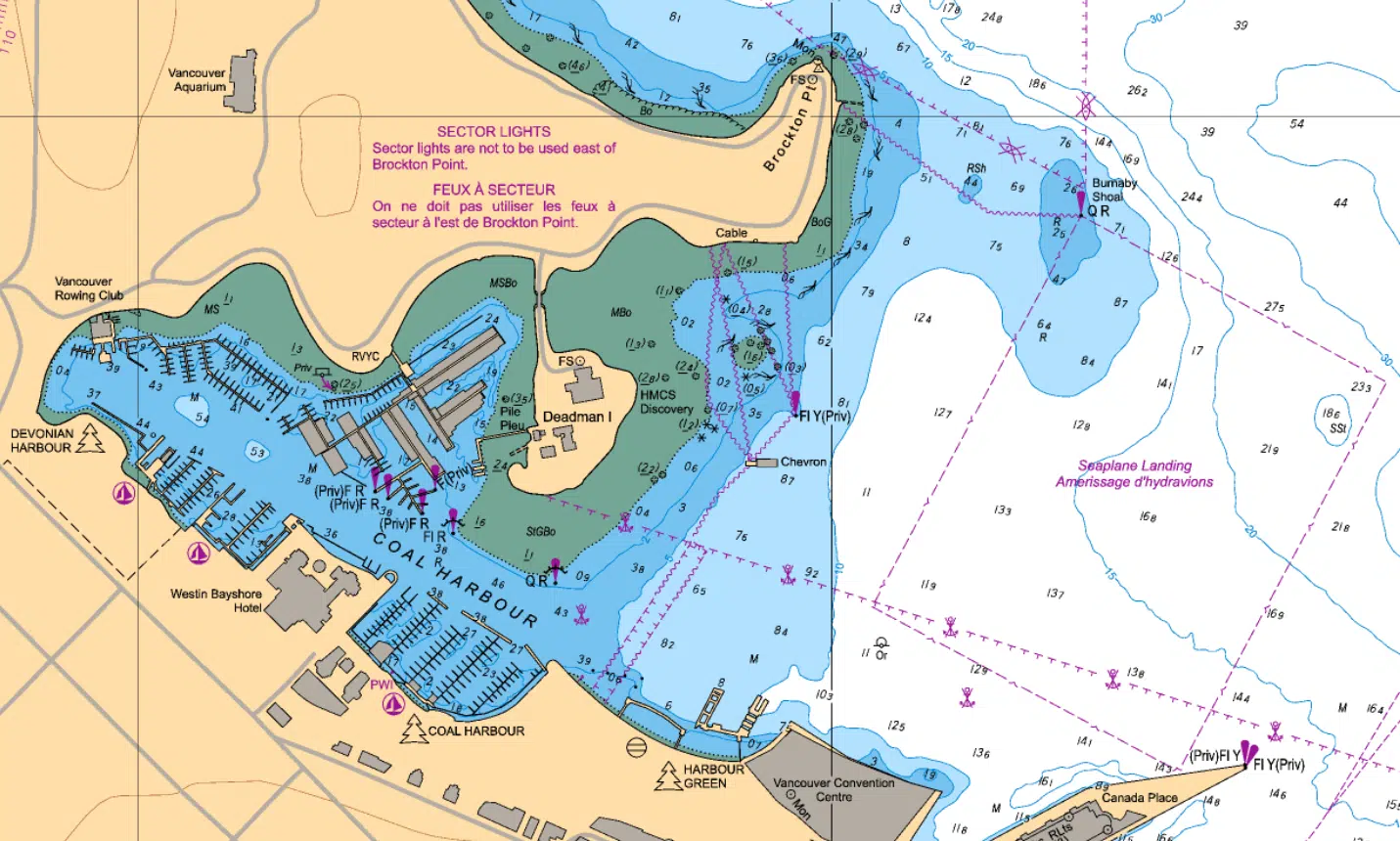
Image courtesy of Fisheries and Oceans Canada
2. Electronic Navigational Chart (ENC)
An ENC is ‘smart’. You can click on different elements and get more information about each one. It can be integrated with other data such as GPS position, radar, planned routes, heading and speed. It can provide warnings about hazards and dangerous situations.
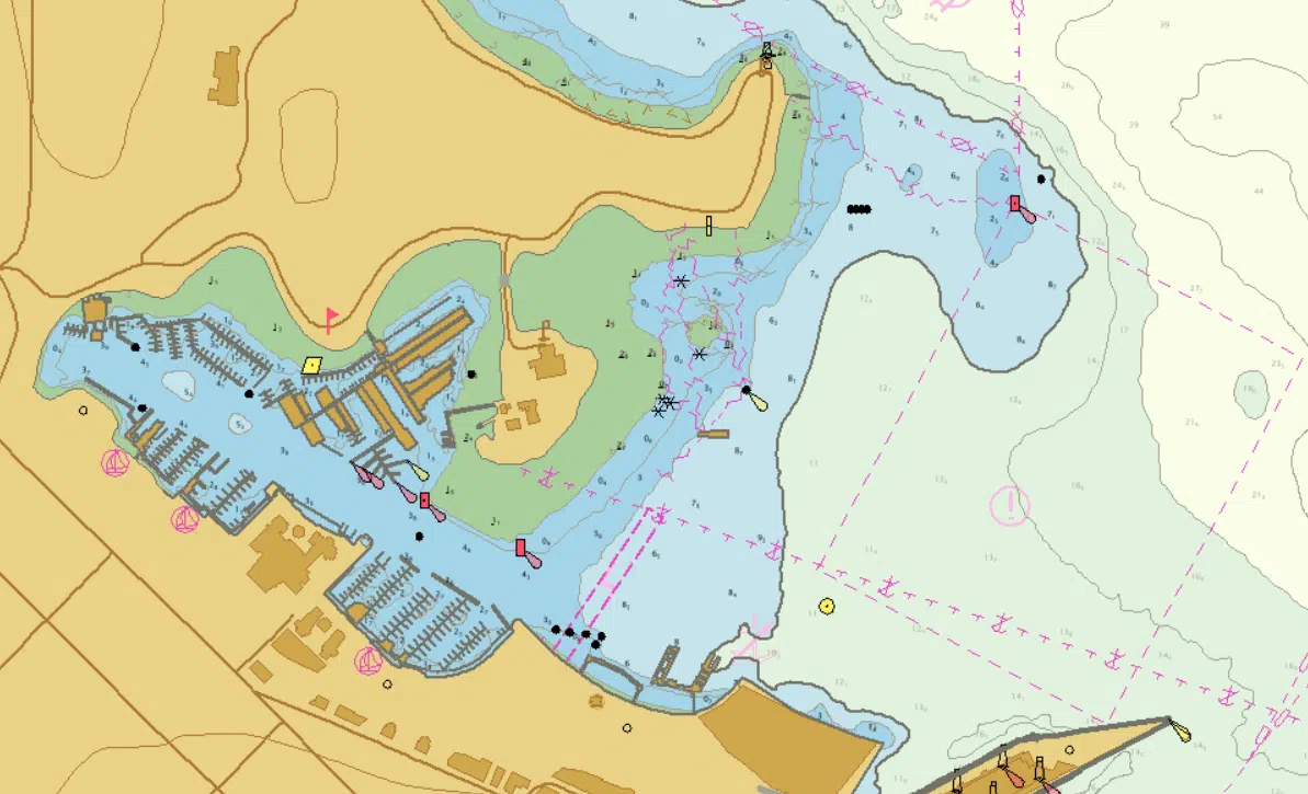
Image courtesy of Fisheries and Oceans Canada
You can purchase charts for navigation on Canadian waterways from a dealer approved by Fisheries and Oceans Canada.
How to read a nautical chart
The Canadian Chart 1 – Symbols, Abbreviations and Terms is the official publication by the Canadian Hydrographic Service (CHS) used to interpret nautical charts. It contains the explanations for all symbols, abbreviations, and terms found on the charts.
Here is a quick overview:
Title block
The title block is a critical section that provides important basic information. Do not overlook this section.
- Seal (or Crest): Identifies the publishing Hydrographic Office (e.g., CHS).
- General Geographic Area: Identifies the region the chart covers.
- Chart Title: Specifies the exact geographic area being charted.
- Projection Identification: Describes the method used to represent the curved earth on a flat chart. The Mercator projection is the most common, as it minimizes shape and direction distortions.
Natural scale
Natural scale refers to the relationship between the chart size and the earth’s size (e.g., 1:15\ 000). Charts are categorized by their scale and intended use.
For example: Approach charts have a scale of 1:20 001 to 1:50 000. They are used for approaching coasts where boat operators require a detailed knowledge of the area to navigate safely.
Depths, elevations, and datums
Specific notes define how measurements are represented on the chart:
- Depths Note: Indicates the units used for water depths (e.g., feet/fathoms or metres/decimetres). All Canadian charts are eventually moving to metres.
- Elevations Note: Describes the datum used for the height of structures, like bridges and overhead cables, which is essential for determining clearance.
- Horizontal Datum: Describes the starting point used for accurately positioning objects on the earth’s surface.
Measuring tools
Charts include several tools and supplementary notes for navigation:
- Scales: Graphic scales (lines/bars) subdivided into nautical feet, miles, or metres, used for measuring distances.
- Compass rose: Indicates magnetic variation (the difference between true North and magnetic North) and its annual change, which is necessary for determining your location and mapping a safe route using a magnetic compass.
- Edition date and numbers: Located in the lower left, indicating the publication date (month, day, year). Always use a nautical chart that is up to date.
- Insets: Smaller-scale charts within the main chart used to show areas that require more detail (e.g., marinas, small channels) than the main chart’s scale allows.
Canadian Tide and Current Tables
The Canadian Tide and Current Tables provide boaters with important information about navigational conditions.
Tide tables
Tide tables predict the vertical movement of the tides, with details regarding the height of the water at its lowest and highest level and the time of day.
Current tables
Current tables refer to the horizontal movement of the water, with information about slack water times and the maximum velocity of the current.
You can download Canadian tide and current tables for free or try the new IWLS API (online service).
The Canadian Hydrographic Service
The Canadian Hydrographic Service is the main resource for the various types of nautical publications.
In addition, the Canadian Coast Guard publishes navigational warnings and notices, including Notices to Mariners (NOTMAR), updated on a monthly basis.
Get your boating licence with Drive A Boat Canada!
We offer a comprehensive online course leading to lifetime certification. Register with Drive a Boat Canada today, and learn everything you need to know to pass the boating exam. With your boating licence (PCOC), you can take to the water legally anywhere in the country.
Frequently Asked Questions
No. If your vessel is under 100 gross tonnage, you are generally exempt, provided the operator is sufficiently familiar with all local hazards and navigational conditions for safe operation.
Official paper and digital charts must be purchased from an authorized dealer approved by Fisheries and Oceans Canada. Some digital data and basic charts may be free, but official Electronic Navigational Charts (ENCs) are generally sold.
The best source is the official Canadian Hydrographic Service (CHS) / Fisheries and Oceans Canada (DFO) website.
Colors indicate water depth and the foreshore. Blue typically represents very shallow or drying areas, white/light blue is navigable water, and green usually denotes the land that covers and uncovers with the tide.
Check the Edition Date and Number (usually in the lower corner). You should also check the monthly Notices to Mariners (NOTMAR) for mandatory corrections and updates.
Yes, this is normal. Historically, Canadian charts used feet and fathoms. The Canadian Hydrographic Service (CHS) is gradually transitioning all charts to the metric system (metres and decimetres).
Slack water is the moment when the horizontal water current has virtually stopped before reversing direction. It is important for small craft because it offers the easiest and safest time to navigate narrow passages, docking, or inlets.
They predict the times and heights for a few primary reference stations. To find the tide/current for your specific location, you must use the tables’ secondary stations and apply the necessary correction factors (time and height/velocity differences).
No. Weather forecasts provide information about wind and waves. Tide and current tables provide highly accurate, long-term predictions based on astronomical data, which you must consult for navigational planning.
Sources
- Government of Canada Navigation Safety Regulations, 2020 (SOR/2020-216) Consolidated Regulations. https://lois.justice.gc.ca/eng/regulations/SOR-2020-216/page-4.html#h-1263078
- Government of Canada How to read your paper charts Nautical Charts and Services. https://www.charts.gc.ca/help-aide/tips-conseils-eng.html
- Government of Canada What is the difference between a raster chart and a vector chart? Nautical Charts https://www.charts.gc.ca/charts-cartes/digital-electronique/raster-enc-eng.html
- Government of Canada Purchase charts for navigation. Nautical Charts https://www.charts.gc.ca/charts-cartes/purchase-achat/index-eng.html
- Government of Canada Nautical Charts. Nautical Charts and Services. https://www.charts.gc.ca/charts-cartes/index-eng.html
Latest articles
Canada’s PCOC and PCL Rules in 2026
As of December 31, 2025, Transport Canada implemented significant updates to the Pleasure Craft Licence (PCL) system. However, there have been no changes to the Pleasure Craft Operator Card requirements for Canadian boaters. Not sure what this means for your next boating trip? Keep reading to find out what each licence is for and what Read more ›
All About Ontario Boating and Fishing Licences
Planning a fishing trip in Ontario? If you plan on using a motorized boat, you’ll need to bring along both your boating and fishing licenses. Let us walk you through the process of obtaining these federal and provincial licenses, so that you can enjoy Ontario’s beautiful waterways legally as soon as the season opens. Read more ›
Guide to Registering a Boat in Canada
In most cases, boat registration in Canada is optional. However, most boaters will need to obtain another similar piece of documentation, a Pleasure Craft License (PCL). Let’s take a look at the details. The difference between a Pleasure Craft License and Vessel Registration Getting a Pleasure Craft License is one thing. Registering your boat is Read more ›